© Angela M. Lobefaro
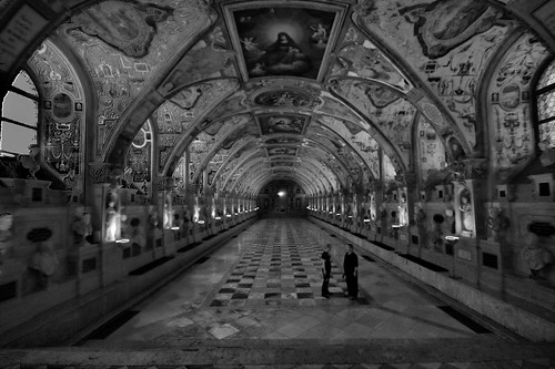
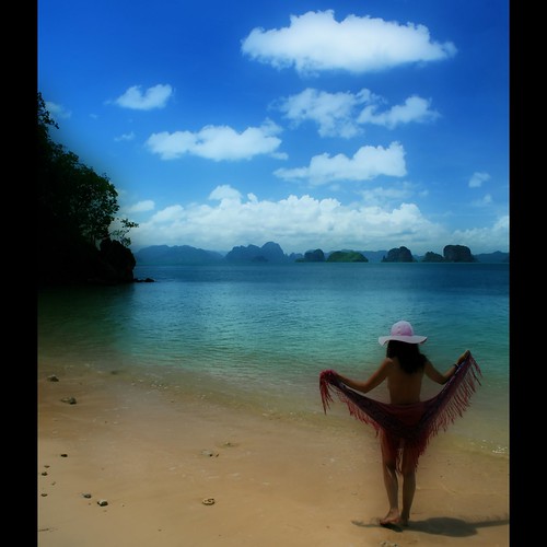
They looks like players of an exotic game or wondering about the symbols around them.
My Most interesting photos for a guy called Isaias
30 November, 2008
Turn 1 - Your Move
29 November, 2008
Looking Forward
© Angela M. Lobefaro
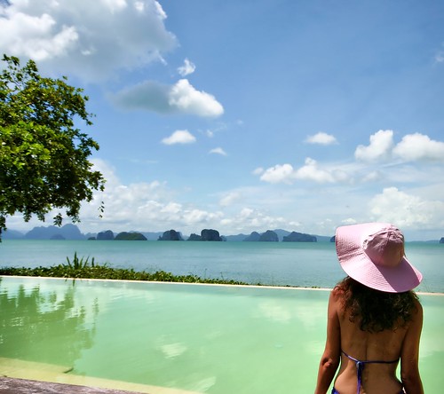
taken in Koh Yao, Thailand. June 2008
My Most interesting photos for a guy called Isaias
Ko Yao (Thai: เกาะยาว) is a district (Amphoe)
Ko Yao (เกาะยาว), sometimes written Koyao, is a group of islands between Phuket and Krabi. There are two main islands, Ko Yao Noi ("Small Long Island") and Ko Yao Yai, with Noi being the more developed of the two.
Ko Yao Noi remains a beautiful island, where most people still believe that the island should be preserved from human degradation.
Sea Gypsies (Moken people) were inhabiting the Bay before anybody else, except maybe other nomadic people like forest hunters and collectors (Sakai, Negritos). The 3,500 or so inhabitants of Koh Yao Noi are thought to be recent migrants from the Malay Peninsula (Satun, Trang).
The Mon population, linguistically and culturally belonging to the Khmer ethnolinguistic group, did settled in peninsular Thailand since ever, ruling maritime states like the one of Ligor (Nakhon Si Thammarat). They melt continuously with Southern migrants from Malaysia and with Northern rulers (Thai), over centuries of commercial exchanges and political conflicts. Most probably the Mon stock remains prevalent for most of the people living nowadays in Southern Thailand, including people of Koh Yao.
Numerous cave paintings hidden in the many islands of the bay, extending from 2000 years ago to last century, attest the influence of distinct communities in the emergence of a mixed origin population, living now in the provinces of Phang Nga, Phuket, Krabi and Satun.
The most recent migrations (17th-18th century) from Satun and Trang to Ko Yao Yai and Koh Yao Noi is attested by the fact that the particular dialect spoken on the island still bear obvious Malaysian lexical traces, particularely regarding toponyms and vernacular names of the flora species.
The main industries on the island are fishing and rubber planting. A little rice farming and some fruit, palm and coconut plantations are evident. Boat building and farming techniques here have been passed from father to son and, while some of the youngsters leave Ko Yao to seek the bright lights of Phuket, most return to their tight knit community
From: en.wikipedia.org/wiki/Amphoe_Ko_Yao
my Explore - Interestingness Set
My Most interesting photos for a guy called Isaias
Subscribe to my stream
Darkr Gallery of my photos
link to my PUBLISHED shots
My Interviews with my Flick Friends!
27 November, 2008
26 November, 2008
The Third Dawn
of a New Year in Flickrland
Second Year on FLickr!
Thank you ALL so much!
Yesterday This week Last week All time
Photos and Videos 1,440 3,399 10,289 877,446
Photostream 327 866 2,530 242,723
Sets 80 234 772 54,185
Collections 0 0 0 0
1,847 4,499 1 3,591 1,174,354 VIEWS!
1,174,354 VIEWS! thanks so much
© Angela M. Lobefaro
taken in Koh Phi Phi Don, Thailand. June 2008
My Most interesting photos for a guy called Isaias
Darkr Gallery of my photos
Subscribe to my stream
My Interviews with my Flick Friends!
The Phi Phi Islands (Thai: หมู่เกาะพีพี) are located in Thailand, between the large island of Phuket and the western Andaman Sea coast of the mainland. Phi Phi Don, the larger and principal of the two Phi Phi islands, is located at [show location on an interactive map] 7°44′00″N, 98°46′00″E. Both Phi Phi Don, and Phi Phi Leh, the smaller, are administratively part of Krabi province, most of which is on the mainland, and is located at [show location on an interactive map] 8°02′30″N, 98°48′39″E.
Ko Phi Phi Don ("ko" (Thai: เกาะ) meaning "island" in the Thai language) is the largest island of the group, and is the only island with permanent inhabitants, although the beaches of the second largest island, Ko Phi Phi Lee (or "Ko Phi Phi Leh"), are visited by many people as well. There are no accommodation facilities on this island, but it is just a short boat ride from Ko Phi Phi Don. The rest of the islands in the group, including Bida Nok, Bida Noi, and Bamboo Island, are not much more than large limestone rocks jutting out of the sea.
Phi Phi Don was initially populated by Muslim fishermen during the late 1940s, and later became a coconut plantation. The Thai population of Phi Phi Don remains more than 80% Muslim.But the actual population if counting laborers, especially from the north-east, from the mainland is much more Buddhist these days.
Ko Phi Phi Leh was the backdrop for the 2000 movie The Beach. Phi Phi Leh also houses the 'Viking Cave', from which there is a thriving bird's nest soup industry. There was criticism during filming of 'The Beach' that the permission granted to the film company to physically alter the environment inside Phi Phi Islands National Park was illegal. [1] The controversy cooled down however, when it was discovered that the producers had done such a decent job of restoring the place that it finally looked better than it had done before.
Following the release of The Beach, tourism on Phi Phi Don increased dramatically, and with it the population of the island. Many buildings were constructed without planning permission.[citation needed]
Ko Phi Phi was devastated by the Indian Ocean tsunami of December 2004, when nearly all of the island's infrastructure was wiped out. Redevelopment has, however, been swift, and services like electricity, water, Internet access and ATMs are up and running again, but waste handling has been slower to come back online.
My Most interesting photos for a guy called Isaias
Darkr Gallery of my photos
Subscribe to my stream
My Interviews with my Flick Friends!
from: en.wikipedia.org/wiki/Phi_Phi_Island
.
25 November, 2008
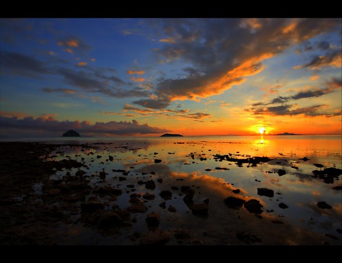
Ko Lanta Rock Beach

© Angela M. Lobefaro
taken in Ko Lanta - Krabi - Thailand
My Most interesting photos for a guy called Isaias
Darkr Gallery of my photos
Subscribe to my stream
My Interviews with my Flick Friends!
.
24 November, 2008
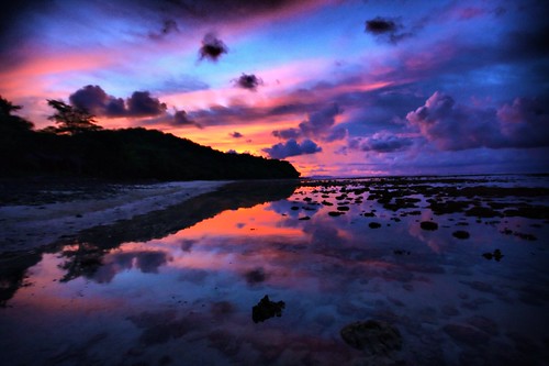
We Are Not Meant to Be Alone
Sunset
taken in Koh Phi Phi Don, Thailand. June 2008
The Phi Phi Islands (Thai: หมู่เกาะพีพี) are located in Thailand, between the large island of Phuket and the western Andaman Sea coast of the mainland. Phi Phi Don, the larger and principal of the two Phi Phi islands, is located at [show location on an interactive map] 7°44′00″N, 98°46′00″E. Both Phi Phi Don, and Phi Phi Leh, the smaller, are administratively part of Krabi province, most of which is on the mainland, and is located at [show location on an interactive map] 8°02′30″N, 98°48′39″E.
Ko Phi Phi Don ("ko" (Thai: เกาะ) meaning "island" in the Thai language) is the largest island of the group, and is the only island with permanent inhabitants, although the beaches of the second largest island, Ko Phi Phi Lee (or "Ko Phi Phi Leh"), are visited by many people as well. There are no accommodation facilities on this island, but it is just a short boat ride from Ko Phi Phi Don. The rest of the islands in the group, including Bida Nok, Bida Noi, and Bamboo Island, are not much more than large limestone rocks jutting out of the sea.
Phi Phi Don was initially populated by Muslim fishermen during the late 1940s, and later became a coconut plantation. The Thai population of Phi Phi Don remains more than 80% Muslim.But the actual population if counting laborers, especially from the north-east, from the mainland is much more Buddhist these days.
Ko Phi Phi Leh was the backdrop for the 2000 movie The Beach. Phi Phi Leh also houses the 'Viking Cave', from which there is a thriving bird's nest soup industry. There was criticism during filming of 'The Beach' that the permission granted to the film company to physically alter the environment inside Phi Phi Islands National Park was illegal. [1] The controversy cooled down however, when it was discovered that the producers had done such a decent job of restoring the place that it finally looked better than it had done before.
Following the release of The Beach, tourism on Phi Phi Don increased dramatically, and with it the population of the island. Many buildings were constructed without planning permission.[citation needed]
Ko Phi Phi was devastated by the Indian Ocean tsunami of December 2004, when nearly all of the island's infrastructure was wiped out. Redevelopment has, however, been swift, and services like electricity, water, Internet access and ATMs are up and running again, but waste handling has been slower to come back online.
my Explore - Interestingness Set
My Most interesting photos for a guy called Isaias
Subscribe to my stream
Darkr Gallery of my photos
link to my PUBLISHED shots
My Interviews with my Flick Friends!
22 November, 2008
My Inspiration Point
© Angela M. Lobefaro
Sunset
taken in Koh Phi Phi Don, Thailand. June 2008
My Most interesting photos for a guy called Isaias
21 November, 2008
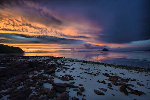
Ko Yao Memories
© Angela M. Lobefaro
taken in Koh Yao, Thailand. June 2008
My Most interesting photos for a guy called Isaias
Ko Yao (Thai: เกาะยาว) is a district (Amphoe)
Ko Yao (เกาะยาว), sometimes written Koyao, is a group of islands between Phuket and Krabi. There are two main islands, Ko Yao Noi ("Small Long Island") and Ko Yao Yai, with Noi being the more developed of the two.
Ko Yao Noi remains a beautiful island, where most people still believe that the island should be preserved from human degradation.
Sea Gypsies (Moken people) were inhabiting the Bay before anybody else, except maybe other nomadic people like forest hunters and collectors (Sakai, Negritos). The 3,500 or so inhabitants of Koh Yao Noi are thought to be recent migrants from the Malay Peninsula (Satun, Trang).
The Mon population, linguistically and culturally belonging to the Khmer ethnolinguistic group, did settled in peninsular Thailand since ever, ruling maritime states like the one of Ligor (Nakhon Si Thammarat). They melt continuously with Southern migrants from Malaysia and with Northern rulers (Thai), over centuries of commercial exchanges and political conflicts. Most probably the Mon stock remains prevalent for most of the people living nowadays in Southern Thailand, including people of Koh Yao.
Numerous cave paintings hidden in the many islands of the bay, extending from 2000 years ago to last century, attest the influence of distinct communities in the emergence of a mixed origin population, living now in the provinces of Phang Nga, Phuket, Krabi and Satun.
The most recent migrations (17th-18th century) from Satun and Trang to Ko Yao Yai and Koh Yao Noi is attested by the fact that the particular dialect spoken on the island still bear obvious Malaysian lexical traces, particularely regarding toponyms and vernacular names of the flora species.
The main industries on the island are fishing and rubber planting. A little rice farming and some fruit, palm and coconut plantations are evident. Boat building and farming techniques here have been passed from father to son and, while some of the youngsters leave Ko Yao to seek the bright lights of Phuket, most return to their tight knit community
From: en.wikipedia.org/wiki/Amphoe_Ko_Yao
19 November, 2008
Venice, what else ?
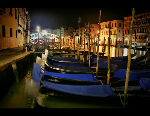
hand held shot taken during a photo walk with Don (dgjean) - Nov '07
Please take a look at my interview with my flickr friend:
DON aka dgjean
new link for Don: www.flickr.com/photos/donald_jean/
Interestingness shots
50 Most interesting slide show
btw : link to my PUBLISHED shots
Subscribe to my stream
18 November, 2008
Nova Ghost Edition

taken in Paris - Montmartre - August '07
take a look at my interview with Mr Bratan :
angiereal.blogspot.com/2007/10/interview-with-my-flickr-f...
Interestingness shots
50 Most interesting slide show
btw : link to my PUBLISHED shots
Subscribe to my stream
16 November, 2008
Shooting Attitude

We had a wonderful flickr meet up today in Vercelli, Piedmont. Italy
Thanks to Daniela bad_winters & to Andreas
for the great day together!
We look forward to meeting you again soon!
12 November, 2008

08 November, 2008
Everything at its place
Everything at its place
© Angela M. Lobefaro
taken in Lago d'Orta - Orta San Giulio.
60 kms from where we live.
06 November, 2008
Cantine Contratto - Canelli
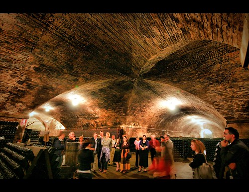
© Angela M. Lobefaro
Since 1876, Casa Contratto has had its home in the heart of Canelli. Its buildings are in elegant Liberty Style, the architectural period between the late 1800s and the early 1900s, when the name Contratto first became famous throughout the world.
Casa Contratto was the first Italian producer to specify the date on the label for Metodo Classico, with its Extra Dry-Brut Riserva Speciale 1917.
www.contratto.it/homepage.htm
04 November, 2008
Laguna Blues
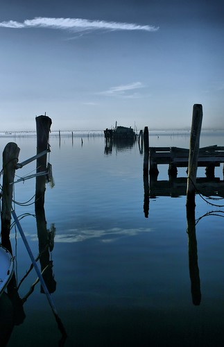
taken in Pellestrina, a small but beautiful island of the Venetian laguna, 10 Km x 500 m
01 November, 2008
Subscribe to:
Posts (Atom)


