© Angela M. Lobefaro
taken in Koh Yao, Thailand. June 2008
My Most interesting photos for a guy called Isaias
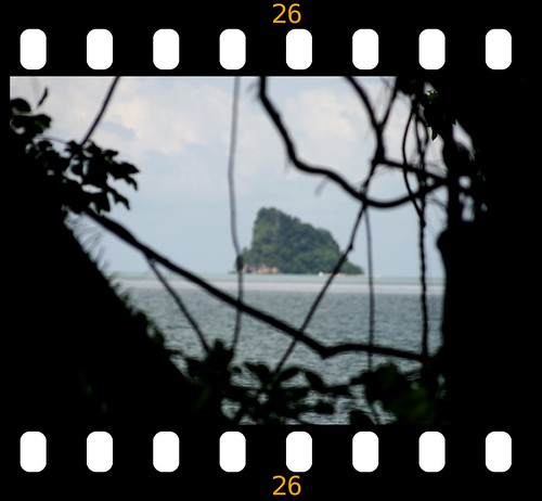
Ko Yao (Thai: เกาะยาว) is a district (Amphoe)
Ko Yao (เกาะยาว), sometimes written Koyao, is a group of islands between Phuket and Krabi. There are two main islands, Ko Yao Noi ("Small Long Island") and Ko Yao Yai, with Noi being the more developed of the two.
Ko Yao Noi remains a beautiful island, where most people still believe that the island should be preserved from human degradation.
Sea Gypsies (Moken people) were inhabiting the Bay before anybody else, except maybe other nomadic people like forest hunters and collectors (Sakai, Negritos). The 3,500 or so inhabitants of Koh Yao Noi are thought to be recent migrants from the Malay Peninsula (Satun, Trang).
The Mon population, linguistically and culturally belonging to the Khmer ethnolinguistic group, did settled in peninsular Thailand since ever, ruling maritime states like the one of Ligor (Nakhon Si Thammarat). They melt continuously with Southern migrants from Malaysia and with Northern rulers (Thai), over centuries of commercial exchanges and political conflicts. Most probably the Mon stock remains prevalent for most of the people living nowadays in Southern Thailand, including people of Koh Yao.
Numerous cave paintings hidden in the many islands of the bay, extending from 2000 years ago to last century, attest the influence of distinct communities in the emergence of a mixed origin population, living now in the provinces of Phang Nga, Phuket, Krabi and Satun.
The most recent migrations (17th-18th century) from Satun and Trang to Ko Yao Yai and Koh Yao Noi is attested by the fact that the particular dialect spoken on the island still bear obvious Malaysian lexical traces, particularely regarding toponyms and vernacular names of the flora species.
The main industries on the island are fishing and rubber planting. A little rice farming and some fruit, palm and coconut plantations are evident. Boat building and farming techniques here have been passed from father to son and, while some of the youngsters leave Ko Yao to seek the bright lights of Phuket, most return to their tight knit community
From: en.wikipedia.org/wiki/Amphoe_Ko_Yao
31 March, 2009
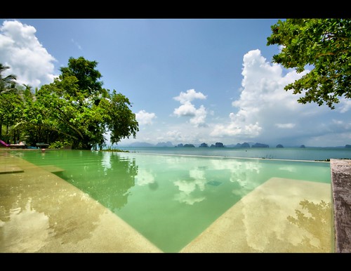
The V pool
30 March, 2009
Ko Yao Jungle Style
© Angela M. Lobefaro
taken in Koh Yao, Thailand. June 2008
My Most interesting photos for a guy called Isaias
Ko Yao (Thai: เกาะยาว) is a district (Amphoe)
Ko Yao (เกาะยาว), sometimes written Koyao, is a group of islands between Phuket and Krabi. There are two main islands, Ko Yao Noi ("Small Long Island") and Ko Yao Yai, with Noi being the more developed of the two.
Ko Yao Noi remains a beautiful island, where most people still believe that the island should be preserved from human degradation.
Sea Gypsies (Moken people) were inhabiting the Bay before anybody else, except maybe other nomadic people like forest hunters and collectors (Sakai, Negritos). The 3,500 or so inhabitants of Koh Yao Noi are thought to be recent migrants from the Malay Peninsula (Satun, Trang).
The Mon population, linguistically and culturally belonging to the Khmer ethnolinguistic group, did settled in peninsular Thailand since ever, ruling maritime states like the one of Ligor (Nakhon Si Thammarat). They melt continuously with Southern migrants from Malaysia and with Northern rulers (Thai), over centuries of commercial exchanges and political conflicts. Most probably the Mon stock remains prevalent for most of the people living nowadays in Southern Thailand, including people of Koh Yao.
Numerous cave paintings hidden in the many islands of the bay, extending from 2000 years ago to last century, attest the influence of distinct communities in the emergence of a mixed origin population, living now in the provinces of Phang Nga, Phuket, Krabi and Satun.
The most recent migrations (17th-18th century) from Satun and Trang to Ko Yao Yai and Koh Yao Noi is attested by the fact that the particular dialect spoken on the island still bear obvious Malaysian lexical traces, particularely regarding toponyms and vernacular names of the flora species.
The main industries on the island are fishing and rubber planting. A little rice farming and some fruit, palm and coconut plantations are evident. Boat building and farming techniques here have been passed from father to son and, while some of the youngsters leave Ko Yao to seek the bright lights of Phuket, most return to their tight knit community
From: en.wikipedia.org/wiki/Amphoe_Ko_Yao
27 March, 2009
No need to argue
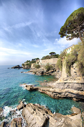
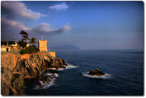
© Angela M. Lobefaro
taken on my birthday in Nervi, Liguria. Italy
Nervi is a former fishing village , now a seaside resort in Liguria, in northwest Italy. Once an independent comune, it is now a quartiere of Genoa. Nervi is 7km east of central Genoa.
Located 25 meters above sea level, Nervi is the oldest winter resort on the Riviera di Levante[2], the part of the Italian Riviera east of Genoa. At the beginning of the century, it's mentioned as being surrounded with groves of olives, oranges and lemons, and beautiful gardened villas. The climate is moist and less dusty than the Riviera di Ponente, the part of the Italian Riviera west of Genoa, and is especially in favor with those who suffer from lung complaints.
from wikipedia
en.wikipedia.org/wiki/Nervi
25 March, 2009
Slice of Life
© Angela M. Lobefaro
taken on my birthday in Nervi, Liguria. Italy
Nervi is a former fishing village , now a seaside resort in Liguria, in northwest Italy. Once an independent comune, it is now a quartiere of Genoa. Nervi is 7km east of central Genoa.
Located 25 meters above sea level, Nervi is the oldest winter resort on the Riviera di Levante[2], the part of the Italian Riviera east of Genoa. At the beginning of the century, it's mentioned as being surrounded with groves of olives, oranges and lemons, and beautiful gardened villas. The climate is moist and less dusty than the Riviera di Ponente, the part of the Italian Riviera west of Genoa, and is especially in favor with those who suffer from lung complaints.
from wikipedia
en.wikipedia.org/wiki/Nervi
24 March, 2009
Water Magnet

© Angela M. Lobefaro
taken in Koh Phi Phi Don, Thailand. June 2008
My Most interesting photos for a guy called Isaias
Darkr Gallery of my photos
Subscribe to my stream
My Interviews with my Flick Friends!
The Phi Phi Islands (Thai: หมู่เกาะพีพี) are located in Thailand, between the large island of Phuket and the western Andaman Sea coast of the mainland. Phi Phi Don, the larger and principal of the two Phi Phi islands, is located at [show location on an interactive map] 7°44′00″N, 98°46′00″E. Both Phi Phi Don, and Phi Phi Leh, the smaller, are administratively part of Krabi province, most of which is on the mainland, and is located at [show location on an interactive map] 8°02′30″N, 98°48′39″E.
Ko Phi Phi Don ("ko" (Thai: เกาะ) meaning "island" in the Thai language) is the largest island of the group, and is the only island with permanent inhabitants, although the beaches of the second largest island, Ko Phi Phi Lee (or "Ko Phi Phi Leh"), are visited by many people as well. There are no accommodation facilities on this island, but it is just a short boat ride from Ko Phi Phi Don. The rest of the islands in the group, including Bida Nok, Bida Noi, and Bamboo Island, are not much more than large limestone rocks jutting out of the sea.
Phi Phi Don was initially populated by Muslim fishermen during the late 1940s, and later became a coconut plantation. The Thai population of Phi Phi Don remains more than 80% Muslim.But the actual population if counting laborers, especially from the north-east, from the mainland is much more Buddhist these days.
Ko Phi Phi Leh was the backdrop for the 2000 movie The Beach. Phi Phi Leh also houses the 'Viking Cave', from which there is a thriving bird's nest soup industry. There was criticism during filming of 'The Beach' that the permission granted to the film company to physically alter the environment inside Phi Phi Islands National Park was illegal. [1] The controversy cooled down however, when it was discovered that the producers had done such a decent job of restoring the place that it finally looked better than it had done before.
Following the release of The Beach, tourism on Phi Phi Don increased dramatically, and with it the population of the island. Many buildings were constructed without planning permission.[citation needed]
Ko Phi Phi was devastated by the Indian Ocean tsunami of December 2004, when nearly all of the island's infrastructure was wiped out. Redevelopment has, however, been swift, and services like electricity, water, Internet access and ATMs are up and running again, but waste handling has been slower to come back online.
My Most interesting photos for a guy called Isaias
Darkr Gallery of my photos
Subscribe to my stream
My Interviews with my Flick Friends!
from: en.wikipedia.org/wiki/Phi_Phi_Island
.
22 March, 2009
Postcard from Nervi (Italy)
© Angela M. Lobefaro
taken on my birthday in Nervi, Liguria. Italy
Nervi is a former fishing village , now a seaside resort in Liguria, in northwest Italy. Once an independent comune, it is now a quartiere of Genoa. Nervi is 7km east of central Genoa.
Located 25 meters above sea level, Nervi is the oldest winter resort on the Riviera di Levante[2], the part of the Italian Riviera east of Genoa. At the beginning of the century, it's mentioned as being surrounded with groves of olives, oranges and lemons, and beautiful gardened villas. The climate is moist and less dusty than the Riviera di Ponente, the part of the Italian Riviera west of Genoa, and is especially in favor with those who suffer from lung complaints.
from wikipedia
en.wikipedia.org/wiki/Nervi
21 March, 2009
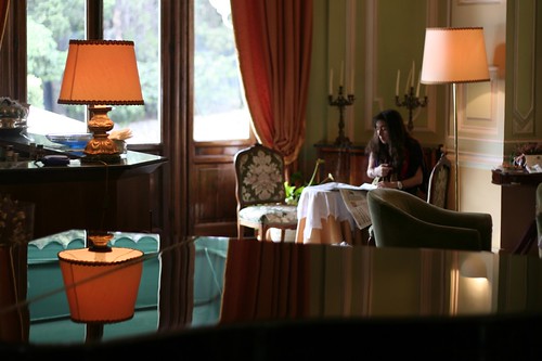
Form follows function
© Angela M. Lobefaro
taken on my birthday in Nervi, Liguria. Italy
en.wikipedia.org/wiki/Form_follows_function
Nervi is a former fishing village , now a seaside resort in Liguria, in northwest Italy. Once an independent comune, it is now a quartiere of Genoa. Nervi is 7km east of central Genoa.
Located 25 meters above sea level, Nervi is the oldest winter resort on the Riviera di Levante[2], the part of the Italian Riviera east of Genoa. At the beginning of the century, it's mentioned as being surrounded with groves of olives, oranges and lemons, and beautiful gardened villas. The climate is moist and less dusty than the Riviera di Ponente, the part of the Italian Riviera west of Genoa, and is especially in favor with those who suffer from lung complaints.
from wikipedia
en.wikipedia.org/wiki/Nervi
Piano Bliss
© Angela M. Lobefaro
taken on my birthday in Nervi, Liguria. Italy
Nervi is a former fishing village , now a seaside resort in Liguria, in northwest Italy. Once an independent comune, it is now a quartiere of Genoa. Nervi is 7km east of central Genoa.
Located 25 meters above sea level, Nervi is the oldest winter resort on the Riviera di Levante[2], the part of the Italian Riviera east of Genoa. At the beginning of the century, it's mentioned as being surrounded with groves of olives, oranges and lemons, and beautiful gardened villas. The climate is moist and less dusty than the Riviera di Ponente, the part of the Italian Riviera west of Genoa, and is especially in favor with those who suffer from lung complaints.
from wikipedia
en.wikipedia.org/wiki/Nervi
17 March, 2009
Fallen Comrades

© Angela M. Lobefaro
Life plays with us, like in a Mikado game
La vita gioca con noi come i bastoncini dello Shanghai
08 March, 2009
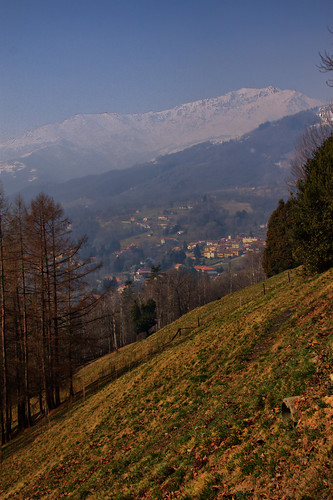
The Burcina Tower
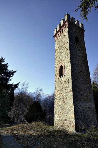
© Angela M. Lobefaro
This tower sit at the top of the hill in a very panoramic position
taken where we live, Burcina Park. Biella, Piedmont, Italy
my first Photo Guide: → HERE
it's part of this site: freephotoguides.blogspot.com/
>> this park was my playground, when I was a child
07 March, 2009
Pagan Offer
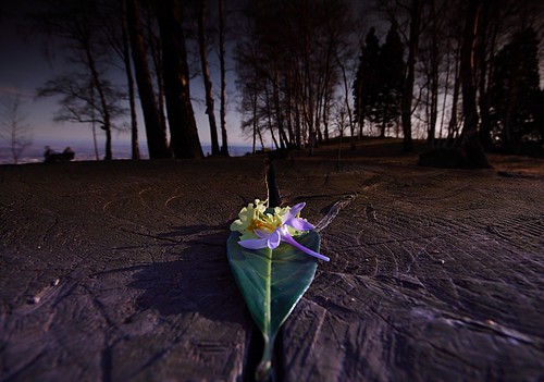
© Angela M. Lobefaro
taken where we live, Burcina Park. Biella, Piedmont, Italy
my first Photo Guide: → HERE
it's part of this site: freephotoguides.blogspot.com/
>> this park was my playground, when I was a child
04 March, 2009
View from the Burcina Park
© Angela M. Lobefaro
taken where we live, Burcina Park. Biella, Piedmont, Italy
my first Photo Guide: → HERE
it's part of this site: freephotoguides.blogspot.com/
>> this park was my playground, when I was a child


